

Exhibitors④
ViSUAL TEChNOLOGY
ViSUAL TEChNOLOGY

| Address | 111-0052 Daini Tosho Center Bldg. 2-1-10 Yanagibashi Taito-ku,Tokyo |
|---|---|
| TEL | 0368236789 |
| FAX | 0368236797 |
| Web site, SNS | https://www.v-t.co.jp/ |
Department of Earth and Environmental Sciences, Graduate School of Environmental studies, Nagoya University
Department of Earth and Environmental Sciences, Graduate School of Environmental studies, Nagoya University


Hydrospheric-Atmospheric Sciences
Education
Admissions
Earth Environmental Systems
 From a systemic perspective, we conduct inter- or trans-disciplinary research and education on the Earth’s environment that results from interactions between nature and human activities.
Ecology

Studies variation of life, animal behavior, and evolution of life in Archean. Research and education are based on field researches.
Geology and Geobiology
 Based on traditional knowledge of geology and paleontology, this group carries out research and education concerning the Earth’s history on a long time scale.
 Geochemistry and Cosmochemistry

Analyze the global environment, including human activities, using various chemical compounds, chemical elements and isotopes.
Earth and Planetary Physics

Explore the origin of the solar system and the evolution/changes occurring on the Earth and other planets by physically analyzing various phenomena.
Earth and Planetary Dynamics

Analyze and predict crustal activities such as earthquakes and volcanic eruptions, based on the latest observational and theoretical studies.
Chronology and Natural History
 Chronological analysis, ranging from the targeting of natural samples, through to specific items related to human activities, as well as the collection, examination, classification and storage of various natural history samples.
Global Environmental Variations
 The aim of this group is to elucidate past events through the analysis of samples obtained from glaciers and growth rings of trees, and understand the present situation.
Climate Science
 Understand the various physical and chemical processes related to climate/global environmental changes, as well as to understand and predict further changes in atmospheric composition.
Global Geochemistry
 Explore the mechanisms and dynamics of biochemical cycles in the atmosphere, hydrosphere and geosphere through field research, laboratory experiments and numerical analyses.
Global Water Cycle
 Investigate processes associated with water circulation in the atmosphere, hydrosphere, and biosphere to improve the understanding of climate variations and environmental problems.
Integrated Environmental Studies Course
| Address | Furo-cho, Chikusa, Nagoya, Aichi 464-8601, JAPAN |
|---|---|
| TEL | +81-52-789-4272 |
| Web site, SNS | http://ees.env.nagoya-u.ac.jp/ |
ELEMENTAR JAPAN K.K.
ELEMENTAR JAPAN K.K.
![]()
Elementar introduces our high-performance analytical instrumentation for stable isotope analysis (IRMS), CHNOS elemental analysis and TOC analysis.
Elementar is the world leader in high-performance analysis of organic and inorganic elements. Today, our product portfolio includes instruments for CHNOS elemental analysis, stable isotope analysis (IRMS), TOC analysis, protein analysis according to Dumas, and optical emission spectrometry (OES).
| Address | 231-0023 Yamashita-cho K-building 9F, 224-1 Yamashita-cho, Naka-ku, Yokohama |
|---|---|
| TEL | 045-323-9182 |
| FAX | 045-323-9184 |
| Web site, SNS | http://www.elementar.com |
The International Joint Graduate Program in Earth and Environmental Sciences, Tohoku University
The International Joint Graduate Program in Earth and Environmental Sciences, Tohoku University
![]()

Program Summary
Curriculum
International Cooperation


This seminar will be open to anyone.
Date: 4 June (Fri) 9:45 – 10:30
Place: Zoom
Contents:
- Introduction of the Department of Earth Science
- Introduction of the Department of Geophysics
- Introduction of SyDE
- Introduction of GP-EES
Click here to join the seminar(Zoom)
| Address | 980-8578 6-3, Aramaki Aza Aoba, Aoba-ku, Sendai 980-8578 JAPAN |
|---|---|
| TEL | 022-795-5577 |
| Web site, SNS | https://gp-ees.tohoku.ac.jp/en/ |
FaCE!S: Fukushima Comprehensive Environmental Site -Now and Future of Environment in Fukushima-
FaCE!S: Fukushima Comprehensive Environmental Site -Now and Future of Environment in Fukushima-
![]()
〇 What will it be?
〇 What shall we take care of?
FaCEIS has mainly 2 contents below;
〇 Database for Radioactive Substance Monitoring Data
Compiled data from environmental monitoring.
〇 Base Information Q&A Site
Compiled information for Q&A style, based on the researches and analysis. It also linked to their sources e.g., papers, reports or other websites.

Click for full-size.
| TEL | 0247-61-2913 |
|---|---|
| FAX | 0247-62-3668 |
| Web site, SNS | https://fukushima.jaea.go.jp/ceis/en |
Progress in Earth and Planetary Science (PEPS journal)
Progress in Earth and Planetary Science (PEPS journal)

(PEPS)
PEPS is a peer-reviewed open-access e-journal of the Japan Geoscience Union(JpGU), published in collaboration with its 51 society members, and deals with scientific articles in the earth and planetary sciences. PEPS was launched in 2014. -Space and Planetary
Sciences
-Atmospheric and
Hydrospheric Sciences
-Human Geosciences
-Solid Earth Sciences
-Biogeosciences
-Interdisciplinary research
(research which covers two or more of the other five science sections)
Recently, there has been an increase in submitting papers for the interdisciplinary research section across multiple research fields, centering on studying natural hazards.
PEPS encourages papers with full data attached: papers with full data attached are scientific articles that preserve the full detailed raw research data and metadata which were gathered in their preparation and make these data freely available to the research community for further analysis.
 PEPS promotes excellent review articles and welcomes articles with electronic attachments including videos, animations, and large original data files.
About 20% of our articles are review articles that provide a systematic summary of the newest developments in their cover.
Now, the collection of review abstracts have been completed.
>>Extract of Review articles abstract collection
 - Impact Factor: 3.604 ( 2-year Impact Factor)
- 5-year Impact Factor: 3.784
- Scopus/CiteScore(2020): 4.7
- SJR: 1.138 ( SCImago Journal Rank )
- SNIP: 1.656 (Source Normalized Impact per Paper)
- Non-member: €1,300
- Review articles: €1,040
- Invited articles: JpGU bears all costs. (100% discount)
We are also looking for new SPEPS proposals.
Please consider SPEPS collections as an effective method to make public session presentations at JpGU Meeting 2021 or the results of research projects.
 Projection and impact assessment of global change
 Evolution and variability of Asian Monsoon and its linkage with Cenozoic global cooling
 Stratigraphy and paleoclimatic/paleoenviromental evolution across the Early–Middle
Pleistocene transition in the Chiba composite section, Japan,and other reference sections in East Asia
 Conservation of geoheritage and cultural heritage; properties, weathering processes, damage assessment and non-destructive evaluation
 Variability of the Sun and Its Terrestrial Impact – VarSITI – 5-year summary review
 Subduction-zone megathrust earthquakes: New perspectives from insitu data &
laboratory analyses

High-definition topographic and geophysical data in geosciences
... and more>>
| Address | 113-0032 Japan Geoscience Union, 2-4-16 Yayoi, Bunkyo-ku, Tokyo, 113-0032, Japan |
|---|---|
| TEL | 03-6914-2080 |
| Web site, SNS | http://progearthplanetsci.org/index.html |
Geodynamics Research Center, Ehime University
Geodynamics Research Center, Ehime University

Geodynamics Research Center (GRC) is an international research institute where researchers conduct leading-edge studies on materials and states of the Earth's deep interior in order to reveal dynamics and evolution of the Earth and planets, based on advanced high-pressure experiments and numerical simulations. We investigate various issues of the Earth and planetary sciences, chemical composition of the Earth's lower mantle, materials and structures of the Earth's core, Earth's deep water, internal structure of solar planets and exoplanets and dynamics of the planetary interior, and expand our techniques and knowledge to a field of material sciences for synthesizing novel useful materials such as the world-hardest material "HIME-Diamond".
The radius of the Earth is about 6,400 km, but only 10 km depth is achieved by drillings. The Earth's deep interior is an unreachable place where pressure and temperature at the center are estimated to be respectively 360 GPa and 5000 K or higher. Thus, high-pressure and temperature experiments and numerical simulations are essential tools to study dynamics and composition under such extreme conditions. Developments of the techiniques at GRC lead to an innovative area of high-pressure materials sciences; syntheses of newly novel materials which are obtainable only by high pressure experiments.
◆PRIUS: Premier Research Institute for Ultrahigh-pressure Sciences
GRC operates PRIUS from 2013 which is one of the "Joint Usage / Research Centers" in Japan authorized by the Ministry of Education, Culture, Sports, Science and Technology. Missions of PRIUS, as an international education and research hub, are to conduct Earth and planetary science and material science research by using the high-pressure techniques with the objective of creating new fields of science thorough the international collaborations and interdisciplinary networks of researchers.
GRC conducts experiments under conditions of ultra high pressure and high temperature experiments of the Earth's and planetary deep interiors by using two types of high-pressure generationg appaturs: Munti-anvil high-pressure apparatus and Diamond anvil cell apparatua. GRC is equipped with several types of Multi-anvil apparatus, including the world-largest class one of 6000-ton press, BOTCHAN.
◆Phase transitions of minerals
A “phase transition” is characterized by the change of configuration of a toms in mineral by the effect of pressure. Diamond is a high pressure form of graphite, whose phase transition occurs at 5 GPa (150 km depth). Measurements of the conditions where the phase transitions occur and changes of the physical properties of minerals (density, sound velocity, chemical properties etc) accompanying the phase transition bring fruitful information for understandings of the Earth's deep structure and materials.
◆Numeral simulations
Ab initio computations: Theoretical and computational investigation on the
ultrahigh-pressure behaviors of materials in the Earth and planets are conducted by using computer simulations based on quantum mechanics.
Fluid mechanics computation: Numerical simulations based on the fluid and continuum mechanics are conducted to reveal the convective motions in the mantle and core of the Earth and terrestrial planets for the understandings of the dynamics and evolution processes of the planets. Large scale computations using realistic parameters of the Earth, phase transitions, viscosity and compression behaviors under high pressure, are performed for 3-D spherical-geometry simulations.
HIME-Diamond synthesized in GRC is the hardest diamond and likely the hardest material in the world. Unlike normal diamond made of a single
crystal, HIME-Diamond consists of closely-packed nanometer-sized diamonds (~10 nanometers = one hundred-thousandth millimeters). Thus the HIME-Diamond is also called "Nano-polycrystalline diamond (NPD)".
◆Toward higher pressure generations
Experiments under higher pressure are of importance to investigate the interiors of the Earth and planets. The harder the compression material is, the higher the pressure we can reach and thus HIME-Diamond plays a
major role in future development of experiments at ultrahigh pressure. The high transparency of HIME-Diamond enables high-pressure experiments using optical in-situ observations and synchrotron radiations.
◆Novel polycrystalline materials and gems
GRC conducts syntheses of novel polycrystalline materials by applying techniques learned from making of HIME-Diamond. Nano-polycrystalline
stishovite (NPS) made from silica (SiO2) is one of the novel materials synthesized by GRC. NPS shows excellent physical properties having both hardness and toughness. Garnets (one of the main constituents within the Earth) with a variety of chemical compositions can be synthesized as nano-polycrystalline materials.
| Address | 790-8577 2-5 Bunkyo-cho, Matsuyama, Ehime 790-8577 Japan |
|---|---|
| TEL | 089-927-8165 |
| Web site, SNS | http://grc.ehime-u.ac.jp/en/ |
JAPEX
JAPEX
![]()
| Address | 100-0005 SAPIA Tower, 1-7-12, Marunouchi, Chiyoda-ku, Tokyo, Japan |
|---|---|
| TEL | 03-6268-7130 |
| FAX | 03-6268-7303 |
| Web site, SNS | https://www.japex.co.jp/english/index.html |
MathWorks Japan
MathWorks Japan
![]()
Thank you for visiting the MathWorks booth. If you are interested in the Loren's presentation or have any questions, please feel free to send us a private message or contact us from the MathWorks website.
Overview:
MATLAB has many features that make handling and viewing geospatial data much easier and require much less coding. During this talk, Loren, a geophysicist by training and a MATLAB expert by day, will use MATLAB to demonstrate two different earthquake case studies including:
- Accessing and visualizing geospatial data
- Work with big data
- Reproducible research
Presenter Bio:
Loren has worked at MathWorks for over 30 years. For the first 27 of these years, Loren co-authored several MathWorks products in addition to adding core functionality to MATLAB, including major contributions to the design of the MATLAB language. She is currently part of the Application Engineering team, enabling Loren to spend more time and energy working with customers.
Loren graduated from MIT with a B.Sc. in physics and has a Ph.D. in marine geophysics from the University of California, San Diego, Scripps Institution of Oceanography. She is a Senior Member of IEEE; and she is co-author on several patent inventions. Loren writes about MATLAB on her blog, The Art of MATLAB
Example of Deep Learning: Semantic Segmentation of multispectral imagery
MATLAB Oil and Gas Conference 2019: Seismic Analysis with Wavelets and Deep Learning
Deep Learning Toolbox also covers one-dimensional signals. There are several methods for this. One is using LSTM, a deep neural network that takes time information into account. The other is two-dimensionalization of signals, then application of image deep learning. You can also use the Signal Labeler app for labeling signals.
Signal Processing
Signal Processing Toolbox is used best for pre-processing and analysis of 1D signals such as seismic waves. You can do time synchronization of multiple signals, noise reduction, the extraction of obviously valid features and so on.
Time-Frequency Analysis
One-dimensional signals can also be made two-dimensional by obtaining the spectrum of each time, and applied to image deep learning, such as classification and detection. You can do all these conversions with the functions in Signal Processing Toolbox and Audio Toolbox.
Noise Reduction with Wavelet Transform
Wavelet Transform allows you to decompose the signals and images into different levels of resolution. By using this technique, you can effectively reduce noise while keeping the edges and singularity that the low-pass filter using the Fourier transform will inevitably degrades. You can feel the effect easily using Wavelet Toolbox app and functions.
There are many more features in MATLAB. Please find more videos on MathWorks website and YouTube.
- Videos on MathWorks website
- YouTube MATLAB Channel
MATLAB Drive is a cloud-based file sharing system that makes it easy to share files between faculty and students.
Using a smartphone application called MATLAB Mobile, it is possible to acquire sensor data and conduct experiments and data analysis using MATLAB even in remote classes.
| Web site, SNS | https://www.mathworks.com/ |
|---|
Hiroshima Institute of Plate Convergence Region Research (HiPeR)
Hiroshima Institute of Plate Convergence Region Research (HiPeR)

Hiroshima Institute of Plate Convergence Region Research (HiPeR) is a research center that has been certified as “Centers of Excellence” in Hiroshima University. The staff of the Department of Earth and Planetary Systems, Hiroshima University play a central role in promoting active joint research and educational activities.
<Flyer>
Different important geoscientific phenomena caused by the dynamic processes are occurring frequently and actively at the plate convergence areas on the Earth. HiPeR (Hiroshima Institute of Plate Convergence Region Research) aims to have comprehensive understanding on these important phenomena, dividing them into three major processes of strategic research. These include “deep circulation of rocks and water”, “process and mechanism of fault movements” and “processes of magma generation”. We are aiming to carry out three-pronged research activities including “experiments”, “instrument-based observations” and “fieldwork-based observations”, which would help us to achieve the unified goal of better understanding of plate convergence area materials and events. Please see the below for the details.
<Member>
We, the staff of the Department of Earth and Planetary Systems, Hiroshima University, are promoting active joint research and educational activities with the participation of many members from Japan and overseas. Please see the below for the members of the research center.
Please click the below URL to see the above enlarged poster.
https://drive.google.com/file/d/1MGCIHxEe5GSeXOQa_BYj3VHK93wClWAE/view?usp=sharing
<Activity>
The followings introduce some of the activities of the research center.

Please click the below URL to see the above enlarged poster.
https://drive.google.com/file/d/1uWFJkxfKLh2XbIUOBwk0vtUTs3JWDPiA/view?usp=sharing
| Address | 739-8526 Kagamiyama 1-3-1, Higashi-Hiroshima 739-8526, Japan |
|---|---|
| TEL | 082-424-7460 |
| FAX | 082-424-0735 |
| Web site, SNS | http://hiper.hiroshima-u.ac.jp/en/ |
TSURUMI-SEIKI CO.,LTD
TSURUMI-SEIKI CO.,LTD
![]()
| Address | 230-0031 2-2-20 TSURUMI-CHUO,TSURUMI-KU,YOKOHAMA |
|---|---|
| TEL | 045-521-5252 |
| FAX | 045-521-1717 |
| Web site, SNS | https://tsurumi-seiki.co.jp/ |
SONY Optical Disc Archive
SONY Optical Disc Archive
![]()
| Address | 220-8750 5-1-1 Minatomirai, Nishi-ku, Yokohama-shi, Kanagawa, Japan |
|---|---|
| TEL | 050-3750-1710 |
| Web site, SNS | https://pro.sony/en_LV/technology/optical-disc-archive |
JAXA Earth Observation Research Center (JAXA/EORC)
JAXA Earth Observation Research Center (JAXA/EORC)
JAXA Earth Observation Research Center (EORC) conducts calibration & validation of satellite data, and the Earth science research and application research using those data.
EORC researches in the field of earth science such as global climate change, water cycle, atmospheric environment and crustal movements, using satellite data while developing calibration & validation and analysis methods to improve data accuracy of sensors onboard earth observation satellites. Earth Observation Research Center ![]()
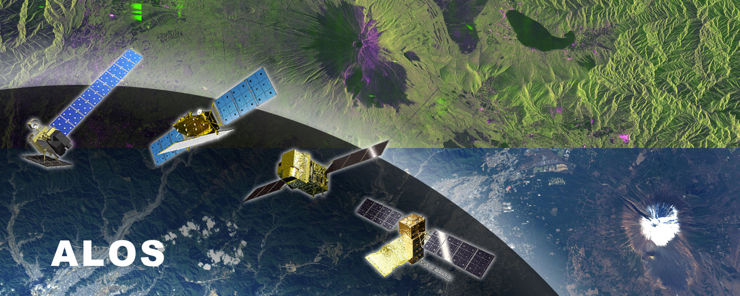 ALOS Research and Application Project conducts the Earth science research and application research using synthetic aperture radar (SAR) and high-resolution optical sensors onboard the Advanced Land Observing Satellite (ALOS) "Daichi" series satellites. ALOS Research and Application Project
 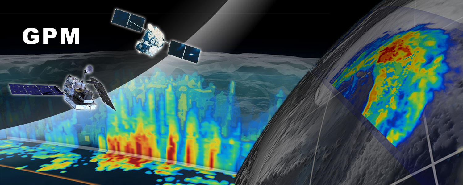 GPM project conducts the Earth science research, application research, and calibration & validation in the field of precipitation and water cycle using the precipitation radar onboard earth observation satellites. The precipitation radar enables observation of three-dimensional structure of rain and snow. GPM Project
 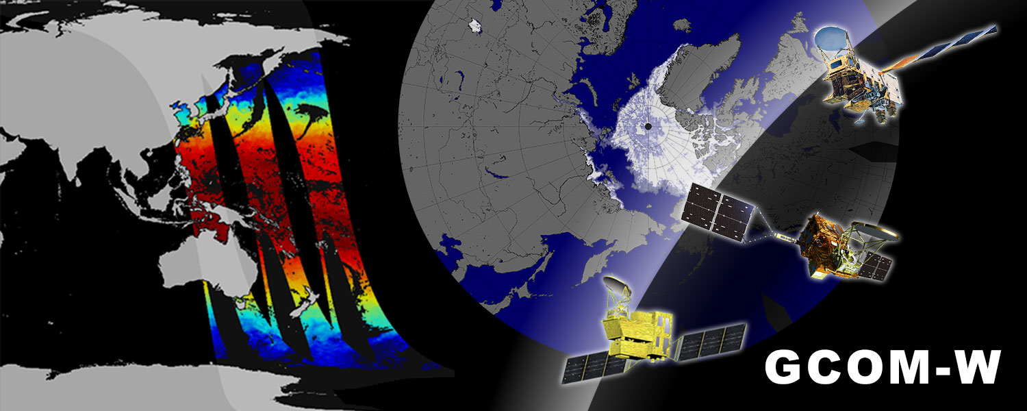 GCOM-W project is conducting the Earth science/application researches and calibration & validation activities related to climate and water cycle variations using the Advanced Microwave Scanning Radiometer (AMSR) series.GCOM-W Project
 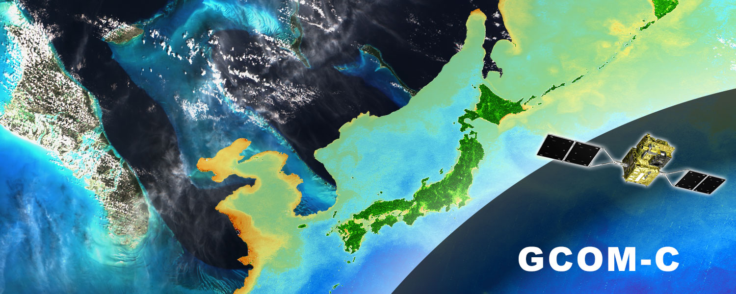 GCOM-C project is conducting the Earth science/application researches and calibration & validation related to climate change using the Second generation GLobal Imager (SGLI) onboard earth observation satellite GCOM-C. GCOM-C Project
 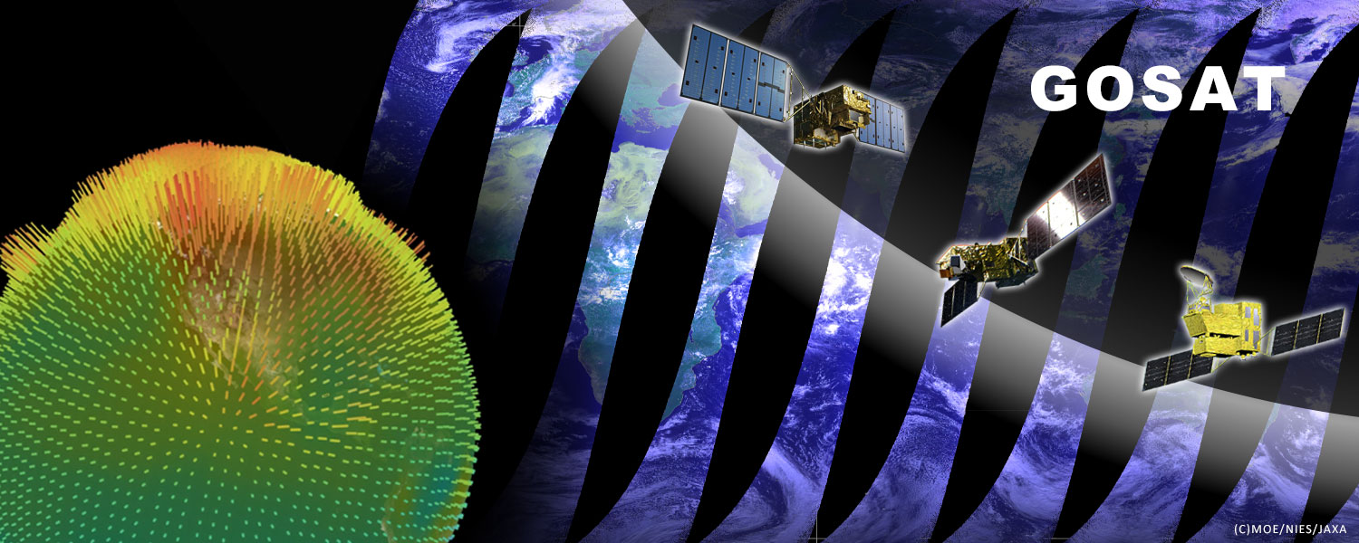 GOSAT project is conducting research and development and data calibration & validation by using sensors onboard the "IBUKI" (GOSAT) series satellites for observing greenhouse gases (carbon dioxide, methane) which are the causes of global warming. GOSAT Project
 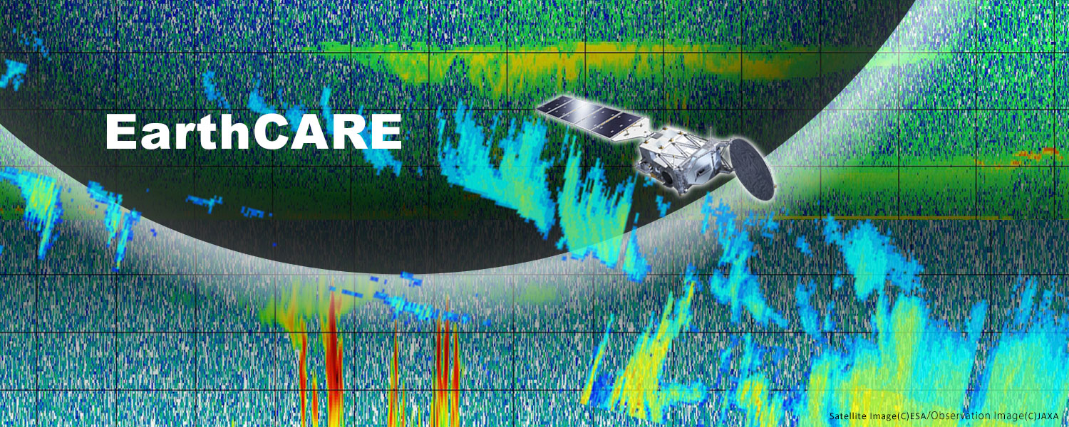 EarthCARE is an earth observation satellite mission that Japan and Europe are collaborating for development. It is expected that the mission will improve the numerical climate model and contribute to improving the accuracy of climate change prediction.EarthCARE Project
Earth Data Collection by JAXA Satellites
The GSMaP provides large amounts of data on hourly rainfall distribution around the world over the past 20 years. You can also see the latest status from the map below.
In addition, JAXA regularly hires aerospace project research associate (fixed-term staff). Please check the JAXA employment opportunities information page for details.JAXA Employment Opportunities

JAXA Satellite Navigator

GCOM_JAXA
| Address | 305-8505 2-1-1 Sengen, Tsukuba-shi, Ibaraki, JAPAN |
|---|---|
| Web site, SNS | https://www.eorc.jaxa.jp/en/ |